Even if we can't see it, water is influencing how the Earth moves every single day. Some GPS sites show amazing sensitivity to these water signals. This presents a problem or an opportunity, depending on your perspective. Geophysicists wanting to study tectonics do not want to see seasonal signals associated with hydrology changes in the Earth. Hydrologists on the other hand, aren't interested in the tectonics, so they remove that effect before looking at what they care about: seasonal changes in position associated with water use. Here we highlight just two applications for GPS that are tied to water use.
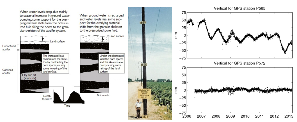
The land over an aquifer is buoyed by the presence of the underground water. The sediments in the aquifer act as a sponge and absorb water into pores. When pumping water for irrigation, the sediments in the aquifer and above settle and the ground level subsides. When the aquifer is recharged through rainfall and snow runoff, the ground level goes back up (Figure 1). If the pumping rate exceeds the recharge rate, the aquifer is being depleted. The water table drops and the land subsides. The aquifer can reach a stage where depletion is so severe that sediments compact, the pores collapse, and the aquifer cannot be recharged.
The San Joaquin Valley in California is a prime example of the effects of pumping for irrigation. In just over 50 years, the ground level subsided as much as 9 meters (Figure 1). By 1999, nearly 1,400,000 hectares of irrigable land, about half of the entire San Joaquin Valley, had significantly subsided. (Also see the USGS report, Land Subsidence in the United States.)

GPS stations in the EarthScope Plate Boundary Observatory clearly see aquifer depletion in California's farming regions. Even though the two GPS stations shown in the right side of Figure 1 are only 75 kilometers apart, GPS station P565 is near farming and P572 is not. Station P565 shows very large signals that are not caused by plate tectonics. In addition to seasonal variations, you can see that in 2009-2011 farmers were recharging the aquifers, so there was no overall downward motion. More pumping in 2012 led to ground subsidence that has not yet recovered. Aquifer depletion is a global problem.
In contrast to aquifers, where the water is in the ground, water on the surface of Earth also causes the crust to move. This is because Earth is elastic. If you put a large weight on it, it will deform. If you take the load off Earth, it returns to its original unloaded shape. Natural causes of surface loading include snowpacks, lakes, and soil moisture. Dams are the quintessential human-created source of surface loading.
Professor Kosuke Heki of Hokkaido University has pioneered the use of GPS to study water loading. Figure 2 shows his results for snow loading using the National GPS Network in Japan. He found that the vertical component of GPS stations moved seasonally in very good agreement with a model of how snow depresses the crust of the Earth.
Last modified: 2019-12-26 16:24:59 America/Denver


Please send comments and corrections to education unavco.org.
Copyright © 2012 - 2026 UNAVCO and the GPS Reflections Research Group.
All Rights Reserved.