GPS is made up of three components: a constellation of satellites, controllers on the ground, and users.
GPS satellites have some special characteristics:
Although initially designed for 24 satellites, the Global Positioning System currently has more than 30 satellites. You can check the GPS constellation status by using this Coast Guard site.
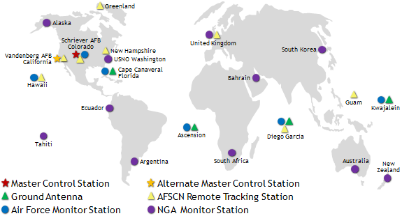
The U.S. Air Force keeps track of the GPS satellites once they're launched, and communicates with them in case there are any problems or updates. It also computes orbits and clock corrections for each satellite so that users can easily calculate their position. In addition to the master control station at Schriever Air Force Base in Colorado, the U.S. operates a global network of tracking stations.

The third component of GPS, users, is sometimes called the ground segment. In order to access GPS, you need:
GPS receivers come in all sizes and shapes. Scientists use the biggest and most expensive GPS receivers. They mount the antenna to bedrock so that it is very stable. Surveyors need almost the same accuracy as scientists, but they usually want the receiver and antenna to be portable. Environmental sensing such as snow depth is a new application for GPS and uses the same receiver as geophysicists. Farmers that use GPS in their tractors don't need to worry about portability, but they do require high accuracy. GPS receivers are routinely used by airplanes for navigation. Animal tracking requires very light GPS units.
Last modified: 2019-12-26 16:24:59 America/Denver


Please send comments and corrections to education unavco.org.
Copyright © 2012 - 2026 UNAVCO and the GPS Reflections Research Group.
All Rights Reserved.