Science Spotlight

Station NVDO


Researcher: Chuck DeMets
University of Wisconsin


NVDO is located at ~4000 m, on the rim of an extinct volcano that overlooks the (active) Volcan Fuego de Colima.


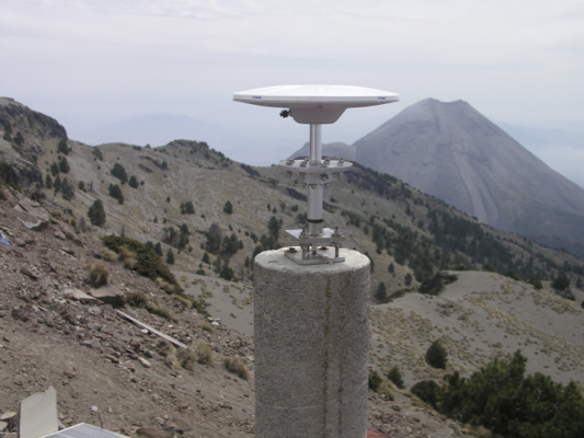
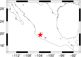
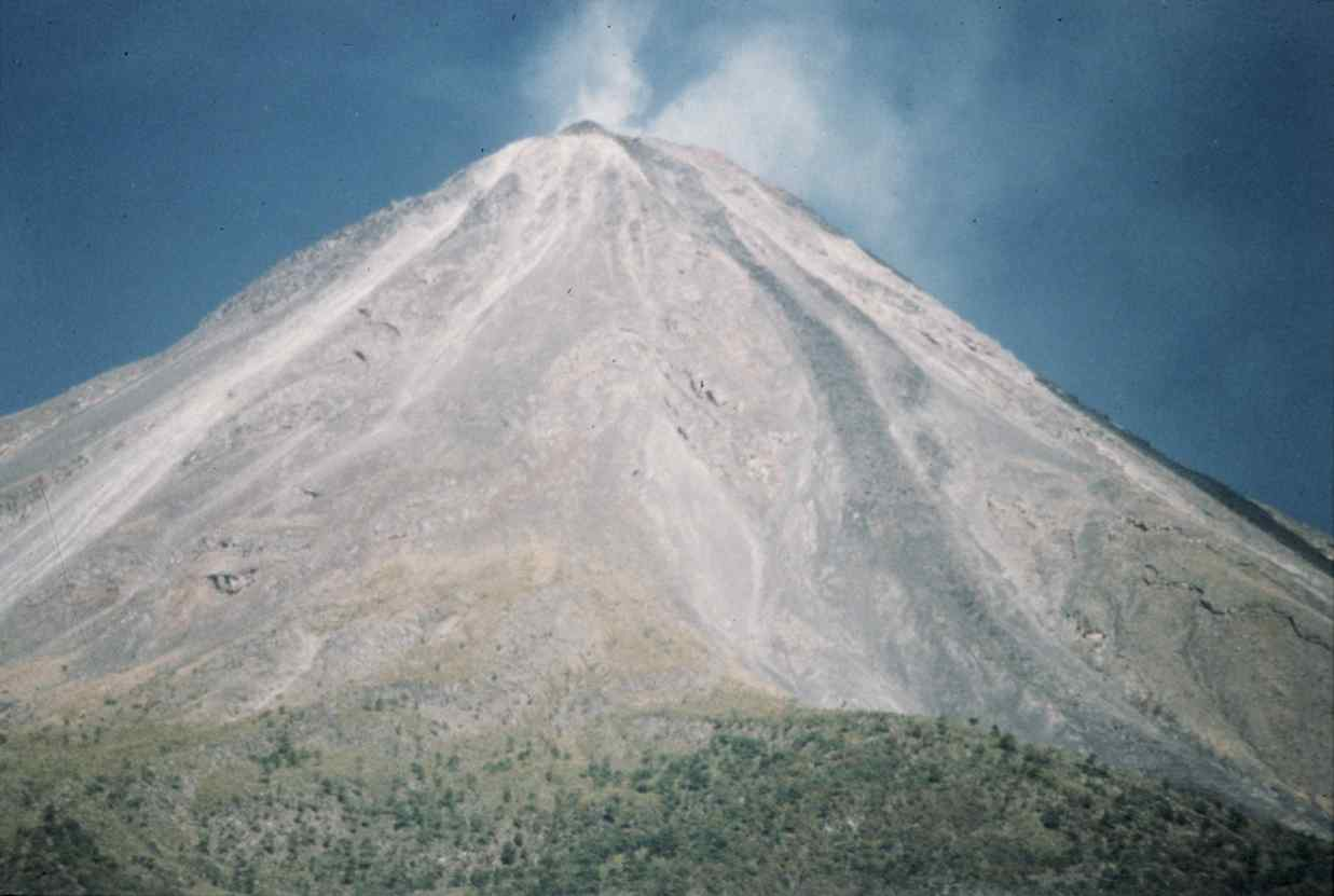
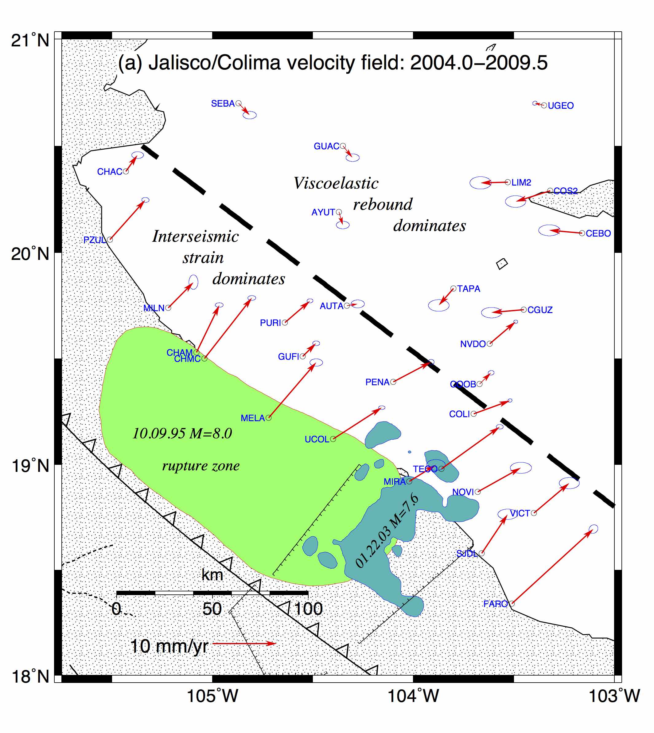
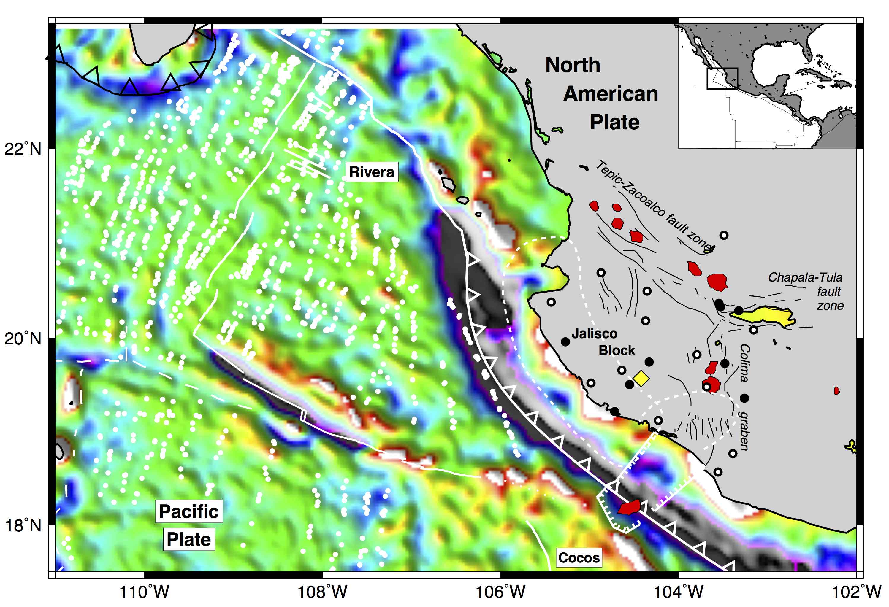
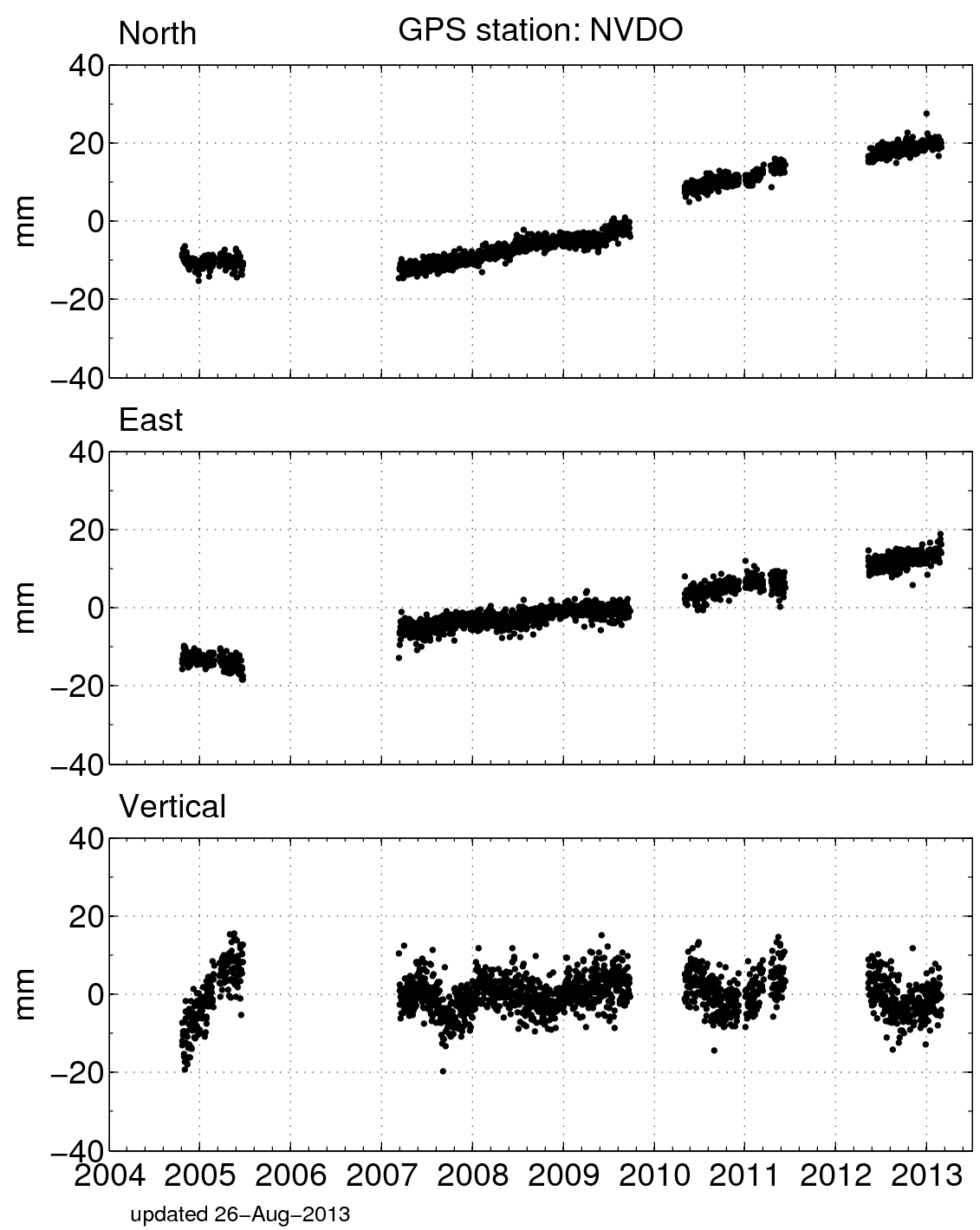
Name: Volcan Nevado de Colima
State: Mexico
Country: Mexico
Elevation: 4002.4 m
Lat/Long:  19.5656 / -103.6164

Volcan Nevado de Colima

Two important geologic hazards in Mexico are eruptions on volcanos and large earthquakes along a the major fault that follows Mexico's Pacific coastline. Measurements at GPS sites offer a useful way to study both processes during the decades or sometimes centuries between major eruptions and earthquakes. Our measurements at GPS site NVDO, which overlooks Volcan Fuego de Colima from the rim of a nearby extinct volcano, permit us to study both processes. As one of the most active volcanos in the Western Hemisphere, Fuego de Colima poses two major threats to the densely populated agricultural state of Jalisco. First, it erupts every 10-20 years, sending ash and lava flows onto nearby areas. Less frequently, eruptions can trigger landslides on the unstable slopes of the volcano. During one major landslide several thousand years ago, boulders and ash swept over the surrounding landscape for more than 70 miles in some directions, burying everything beneath their path and destroying nearly the entire volcano. Such a landslide today would endanger hundreds of thousands of Mexican citizens.

Our GPS measurements at NVDO can tell us several useful things. First, they may detect inflation (mostly uplift) of the nearby Fuego de Colima as magma ascends beneath the volcano before an eruption. Along with GPS, scientists also monitor the volume and composition of gases exhaled by volcanos and the tilt of the volcano's slopes to detect early signs of an impending explosion. The GPS site on on NVDO also moves in response to a steady build-up of strain that can be measured everywhere in the region due to forces that are resisting slip across the major fault off the Pacific Coast. This fault had magnitude 8 earthquakes in 1932, 1995, and 2003 and will surely rupture again when the amount of strain that has built up overcomes the forces that resist movement along the fault. We use GPS measurements at NVDO and other locations in Jalisco to create models of this fault and the rate that strain builds up across it.

Figure 1. Fuego de Colima emits small volumes of noxious gases nearly all the time and is one of the most active volcanos in the western hemisphere.


Figure 3. Since GPS measurements began in Jalisco in 1995, two large magnitude earthquakes have rocked the state of Jalisco: a M8 on Oct. 9 of 1995 and a M7 on Jan. 22 of 2003. Both were recorded by GPS site COLI, which lies just south of the featured site NVDO. In the lower figure panel, the two earthquakes show up as sudden movements of the GPS site. Notice that immediately after both earthquakes, the GPS site locations define a curved line. The curvature is evidence for two processes that are triggered by the earthquake, both at depths of 10 miles or more. One process, called viscoelastic flow, is slow flow of the Earth's hot mantle as it relieves large stresses caused by the earthquake. Another, called fault after slip, represents a strange process where friction that resists slip on a fault changes with time, such that it becomes gradually stronger after an earthquake. Both processes decay in the months and years after an earthquake until what remains is a steady build-up of strain in the crust that sets the stage for the next large earthquake.


Figure 5. This figure shows the average movements of GPS sites, including NVDO, from 2004 to mid-2009. Interestingly, you can see that GPS sites, including NVDO, that are located within roughly 75 km (50 miles) of the Pacific coast, tend to move slowly (1.2 cm per year) toward the interior of the continent. Sites farther inland however move back out toward the ocean! This complex pattern is an outcome of combining the effects of two processes, inter seismic strain accumulation and viscoelastic flow, which cause the surface to move in opposite directions at the same time.


Figure 7. GPS measurements are being made at a one-room school in Oaxaca, Mexico. The GPS equipment is on the right side of the school roof. The school has about 40 students.


Figure 2. Location of the state of Jalisco in western Mexico. The location of the color map relative to the United States is shown in the smaller inset map. Earthquake and volcanic hazards in Jalisco are caused by the collision of the Rivera and Cocos oceanic plates, which dive down into the mantle beneath the western edge of the North America continent in this region. As the two plates descend into the mantle (roughly 2.5 cm per year), they cause earthquakes along their upper contact with the North American continent and volcanism at the locations indicated by the red areas. GPS site NVDO is located on the large, circular red area just west of the text label "Colima graben".


Figure 4. This diagram illustrates some of the important processes that are part of the earthquake cycle and their geometry in a cross-section that shows depth along a line that crosses a subduction fault at right angles. Earthquakes rupture parts of a subduction fault that lie above depths of roughly 25 km (15 miles), where rocks are cool, rigid, and break suddenly when they are under enough stress. "Coseismic rupture" indicates the part of the fault that breaks during an earthquake. The same area is locked by frictional forces that resist fault slip during the decades and centuries between earthquakes. Two other processes described in Figure 3, after slip and viscoelastic flow, are triggered by large earthquakes and occur along deeper areas of the fault and within the mantle underneath the continent.


Figure 6. Here Chuck DeMets is making GPS measurements on a bedrock outcrop in a farmyard in El Guayabo, in the state of Oaxaca.


Figure 8. Position changes for NVDO in a North American fixed reference frame. (For help interpreting the graphs, see the GPS Data page.)

Spotlight Questions

  • What is the cause of volcanic and earthquake hazards in the state of Jalisco in Mexico?
  • If told that "seismic" refers to the earthquake, then which three processes described in the figures are active between large earthquakes? Which of these slowly die away after a large earthquake?
  • Describe similarities between the region of Jalisco and the region of site P405 in the Pacific Northwest.

Last modified: 2019-12-26  16:24:54  America/Denver  


Please send comments and corrections to educationunavco.org.

Copyright © 2012 - 2024 UNAVCO and the GPS Reflections Research Group.
All Rights Reserved.

Funding and Acknowledgements.