Science Spotlight

Station ONSA


Researcher: Joakim Strandberg
Dept. of Earth and Space Sciences
Chalmers University of Technology
Gothenburg, Sweden


The GTGU tide gauge has a unique set up. Two antennas are shown, one pointing up and the other pointing down.


Name: Onsala
Country: Sweden
Elevation: 45.6 m
Lat/Long:  57.3953 / 11.9255

GNSS-R at Onsala

The Onsala Space Observatory is a national research facility in Sweden which hosts a number of measurement instruments, including several GNSS installations. One of these installations is purposefully built for reflectometry measurements of sea level. Two dedicated antennas, one up-looking (called GTGU) and one down-looking (GTGD) are mounted on a pole that extends over open water and connected to commercial GNSS receivers. The site is used as a test installation where different algorithms and equipments can be compared against each other in order to develop new and more precise algorithms for GNSS-Reflectometry (GNSS-R).

Using GNSS-R for measuring sea level is interesting because it can directly tie the sea level measurements to the international terrestrial reference frame, and thus allows positioning of the measurements in an absolute sense. In order to illustrate this, we depict in Figure 2 the time series vertical position estimates of the nearby ONSA station, which has been continuously operated since 1993. Once can clearly identify height changes of several centimeters over the last two decades. Measurements from a traditional tide gauge would not be allow to distinguish between vertical motions and changes in sea-level. Considering the land-uplift trend at Onsala, one would therefore underestimate the sea-level rise. However, a GNSS-R tide gauge is sensitive to both local height motion as well as sea-level rise which makes it possible to measure the absolute changes of the sea surface and thus provide crucial information for monitoring the impacts of global climate change.

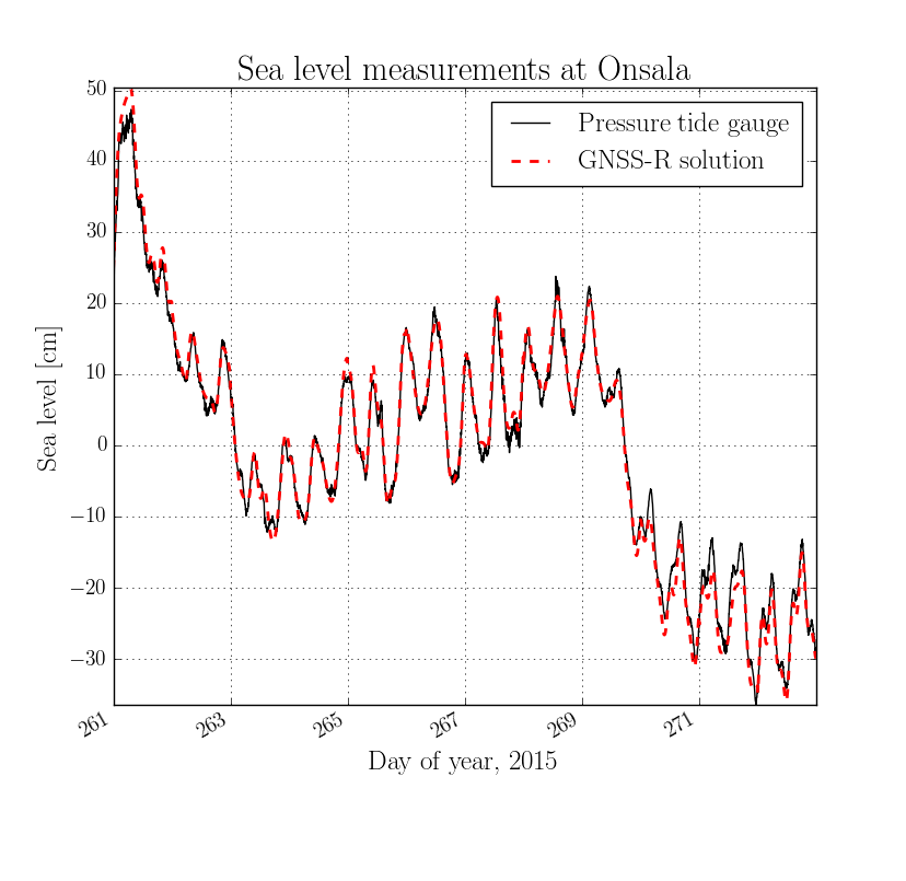
Figure 1. Sea level at Onsala measured with both a conventional pressure-based tide gauge and with GNSS-R.


Figure 3. Multiple radio telescopes, including the newly built Onsala twin-telescopes, and the tide gauge (housed in the red house on the water-front) are examples of geodetic instrumentation at Onsala Space Observatory.


Figure 2. Position change (in ITRF2008) of the nearby geodetic station ONSA, one of the longest operated stations in Sweden. Because of crustal rebound from the last ice age the coast is rising in Scandinavia, which you can see in the vertical panel of this figure.


Last modified: 2019-12-26  16:24:53  America/Denver  


Please send comments and corrections to educationunavco.org.

Copyright © 2012 - 2024 UNAVCO and the GPS Reflections Research Group.
All Rights Reserved.

Funding and Acknowledgements.