Science Spotlight

Station AB33


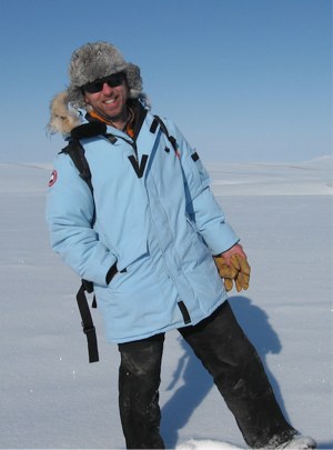
Researcher: Andrew Slater
National Snow and Ice Data Center

We lost Drew in October. He was always a big supporter of PBO H2O. We will miss him.


Photo of the Coldfoot GPS site in April 2013.


Name: COLDFOOT
State: AK
Country: United States
Elevation: 334.8 m
Lat/Long:  67.251 / -150.1725

Snow Measurements in the Yukon River Basin

Why is it important to know about snow at Coldfoot?

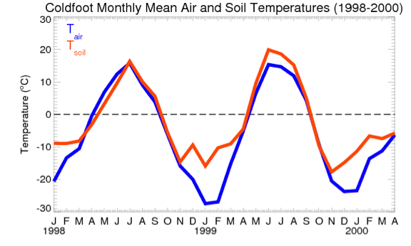
Snow has many physical properties that make it an item of interest, for example, it represents water storage and has high albedo (i.e. it reflects a large amount of sunlight from the surface). However, for a site like Coldfoot, which is underlain by permafrost, snow is an important focus of research because snow is an excellent thermal insulator—that is, snow is very poor at allowing heat (or cold) to pass through it. During the cold Arctic winter, air temperatures can reach below -40°C, but with a covering of 60cm snow the temperature at the ground surface (i.e. at the base of the snow) rarely goes below -10°C. Figure 2 below shows that during winter there is a large difference between air temperatures and 2cm soil temperatures.

In the spring melt season, the amount of snow that accumulated over the winter or spring will also influence the amount of energy that goes into the ground. The more snow there is in the spring, the more energy is needed to melt it—energy that otherwise could have gone into the ground. The energy required to melt snow, i.e. to change snow crystals to water, is quite large; this energy is called the latent heat of fusion. The energy used to melt 1 kg of snow could change the temperature of 1 kg of water by nearly 80°C. With snow cover present, the top of the soil will almost never go above a temperature of 0°C, thus it cannot warm up.

In simple terms we can say that in winter, deeper snow leads to a warmer mean annual soil temperature, while in the spring warm season, deeper snow will lead to a cooler mean annual soil temperature.

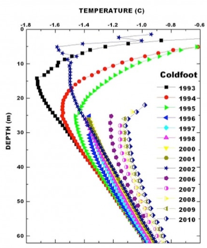
Partly as a result of the insulation provided by the snow, permafrost temperatures in the area around Coldfoot are relatively close to the thawing point and in the past 20 years, permafrost temperatures have been warming (See Figure 3). We need to know what proportion of the increasing ground temperature is due to larger scale factors such as climate change and how much is due to local characteristics of the snow regime.

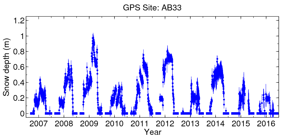
Figure 1. The AB33 GPS data are telemetered to Boulder, Colorado every day and are archived at UNAVCO. The PBO H2O group uses these data to estimate snow depth.


Figure 3. Ground temperatures from a borehole located near the Coldfoot GPS site. At 25m depth, temperatures have warmed more than 0.6°C since 1993. (Courtesy: V. Romanovsky, University of Alaska, Fairbanks)


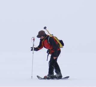
Figure 5. Andrew Slater measuring snow depths using a GPS equipped magna-probe. (Photo: C Heimstra).


Figure 2. Mean monthly 2cm soil temperatures and air temperatures from 1998 to mid-2000 at Coldfoot, Alaska. Note the large difference in temperature during the winter months where snow insulates the ground from the atmosphere.


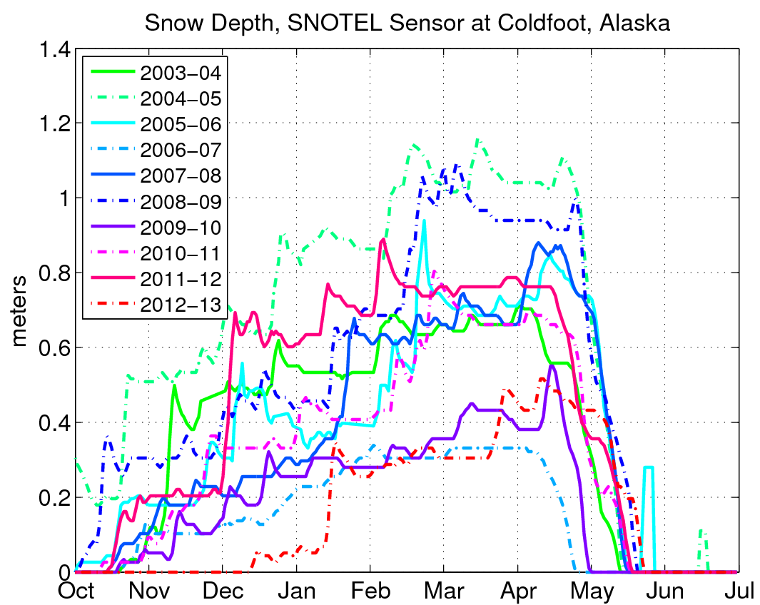
Figure 4. Ten years of snow depth measured by the nearby SNOTEL sensor.


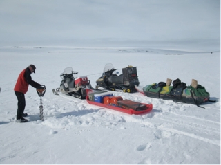
Figure 6. Andrew Slater, drilling in permafrost on the North Slope of Alaska. (Photo: T. Douglas)

Spotlight Questions

  • How well does the snow depth at the GPS site match the snow depth at the SNOTEL site in 2012 and 2013?
  • Do you expect soil temperatures this summer to be higher or lower than usual?
  • Given the rate of change in the borehole temperatures at 25m depth, when would you expect the temperatures at that depth to reach 0°C?

Last modified: 2019-12-26  16:24:58  America/Denver  


Please send comments and corrections to educationunavco.org.

Copyright © 2012 - 2025 UNAVCO and the GPS Reflections Research Group.
All Rights Reserved.

Funding and Acknowledgements.