Science Spotlight

Station SHIP


Researcher: Tadashi Ishikawa
Japanese Coast Guard


In sea floor geodesy, GPS is used to precisely measure the location of a ship.


Name: Offshore
Country: Japan
Elevation: 0.0 m
Lat/Long:  38.297 / 142.372

Seafloor Geodesy and the 2011 Tohoku-Oki Earthquake

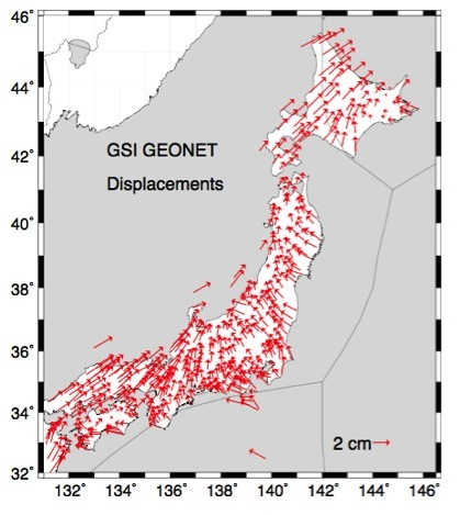
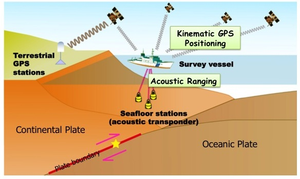
Japan has the largest scientific GPS network in the world (Figure 1). Operated by the Geographical Survey Institute, it can precisely measure crustal deformation rates in Japan. However, it cannot measure how the ground deforms on the sea floor. Since many plate boundaries are offshore, this means one cannot directly measure deformation there with GPS. However, Japan recently began sea floor geodesy experiments (Figure 2). This is a way to measure fault motions offshore.

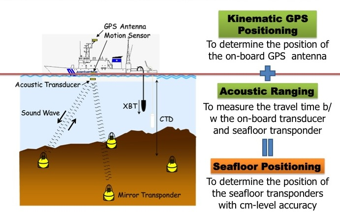
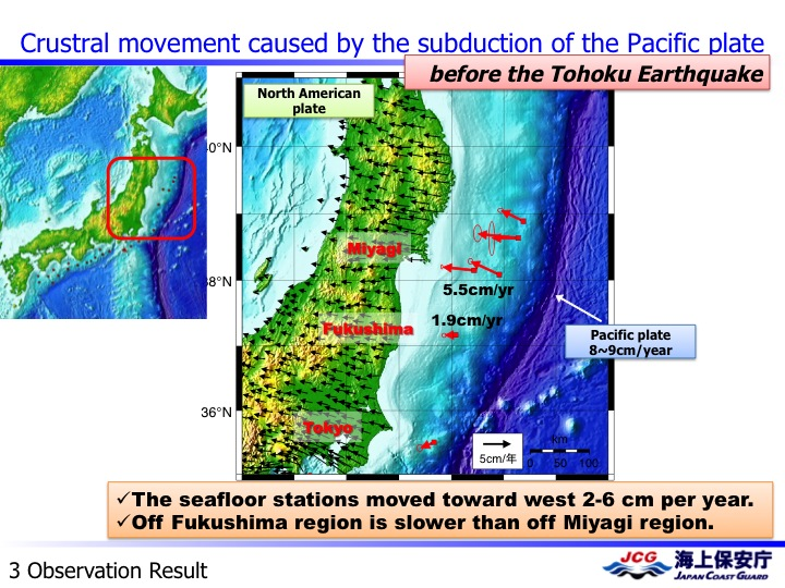
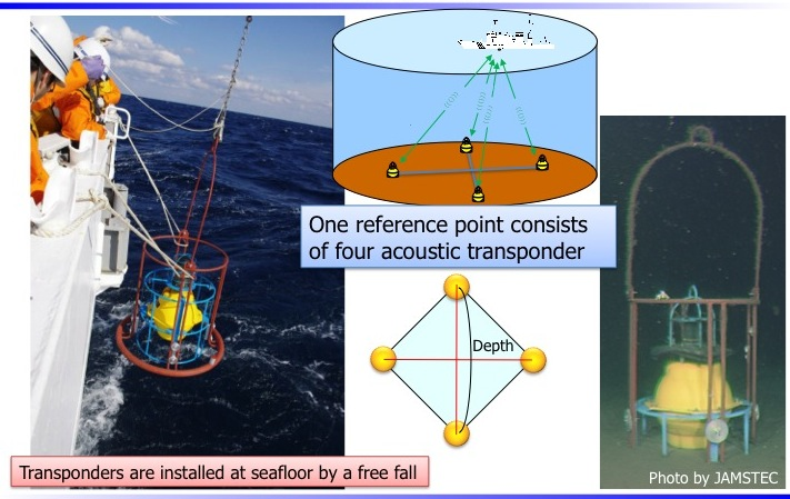
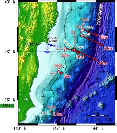
In traditional geodesy, the location of the GPS antenna above a ground marker is measured. In sea floor geodesy, a monument on the sea floor is defined relative to four acoustic transponders (Figure 3). The distance between the transponders (Figure 4) and a ship is then calculated. This is combined with GPS measurements on the ship that calculate its position with respect to the GPS network onland. Small interseismic deformation rates been successfully measured offshore Japan (Figure 5) using this technique. This new method's unique contribution came in 2011, when the first sea floor geodesy measurements of coseismic deformation were made. More than 20 meters of displacement were observed for the great Tohoku-Oki earthquake (Figure 6).

Please read more about Displacement Above the Hypocenter of the 2011 Tohoku-Oki Earthquake in Science. And watch the youtube video of how the ground in Japan moved, as measured by GPS.

Figure 1. Motions of GPS sites for one year, as measured by Geographical Survey Institute. The variations in crustal deformation are caused by the interactions of the four plate tectonic plates, boundaries shown in light gray.


Figure 3. Schematic of how sea floor geodesy data are analyzed. A sound wave from three transponders on the sea floor are measured by acoustic transducers. The sound waves are used to trilaterate the position of the sea floor relative to the ship. The GPS on the ship is then used to calculate where the ship is with respect to the terrestrial reference frame.


Figure 5. Before the great earthquake, the sea floor geodesy technique was used to measure very small motions, of 2-5 cm/year.


Figure 2. Schematic of sea floor geodesy, a system that combines GPS stations on the ground, a ship equipped with GPS, transponders on the sea floor and acoustic ranging.


Figure 4. Photographs of the transponder system, both as it is deployed and on the sea floor.


Figure 6. The red arrows show how much the sea floor moved horizontally during the earthquake - more than 20 meters. Vertical motions are shown as white arrows.


Last modified: 2019-12-26  16:24:49  America/Denver  


Please send comments and corrections to educationunavco.org.

Copyright © 2012 - 2024 UNAVCO and the GPS Reflections Research Group.
All Rights Reserved.

Funding and Acknowledgements.