Science Spotlight

Station INPA


Researcher: David Adams
Research Professor: Universidad Nacional Autonoma de Mexico, Mexico City, Mexico

Research Professor: Universidade do Estado do Amazonas/Instituto Nacional de Pesquisa da Amazonia, Manaus, Amazonas, Brazil.


INPA GPS meteorological station in Manaus, Amazonas, Brazil.


Name: Manaus
State: Brazil
Country: Brazil
Elevation: 97.6 m
Lat/Long:  -3.0959 / -59.9897

The Amazon Dense GPS Meteorological Network

The region of the Amazon Rainforest acts an engine for planet Earth's atmospheric circulation. Most of the sun's energy is absorbed at the surface over equatorial regions of the planet, such as the Amazon Rainforest. This solar energy is used to heat the surface and evaporate water vapor. All of this heat and water vapor at the surface causes the atmosphere to become unstable. When the atmosphere becomes sufficiently unstable, the moist, hot air begins to rise and very large storms are formed which can cause a lot of rainfall and lightning.

What these storms are really doing is transferring the excess energy at the surface to the atmosphere. Given that that these storms occur almost daily of the Amazon Rainforest, the energy that is transferred to the atmosphere then builds up so much that it is forced to to higher latitudes. This is why we say that the equatorial regions act like an engine for the Earth's atmosphere.

How the equatorial atmosphere actually becomes unstable is much more complicated than the basic picture described above. Sometimes, it appears that the atmosphere is very unstable, but it doesn't rain. Other times the atmosphere appears stable and very strong storms form. In order to understand why this happens, we need to carry out long-term (over several years), scientific studies, to be able to see under what conditions rainstorms do or do not form. This is the reason why we brought GPS meteorological stations to the Amazon Rainforest.

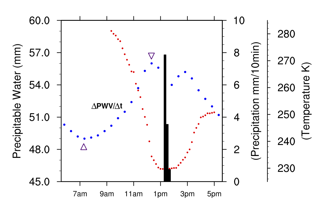
GPS Meteorological stations tells us how fast and how much water vapor is accumulating above the GPS antenna. When sufficient water vapor has accumulated above the antenna, clouds will begin to form. If the atmosphere is unstable, this clouds will grow taller and cause more water vapor to accumulate over the antenna. This process continues until large raindrops form in the clouds and begin to fall under the influence of gravity; that is, what we call rainfall. When the storm finishes the amount of water vapor decreases above the antenna (See Figure 3). When we look at how the water vapor measured by the GPS changes before and after the storm, this gives us an idea of how strong the storm was and how much energy is transferred to the atmosphere. We can also look at other variables such as how tall the clouds were. We use satellites in space to make these cloud measurements.

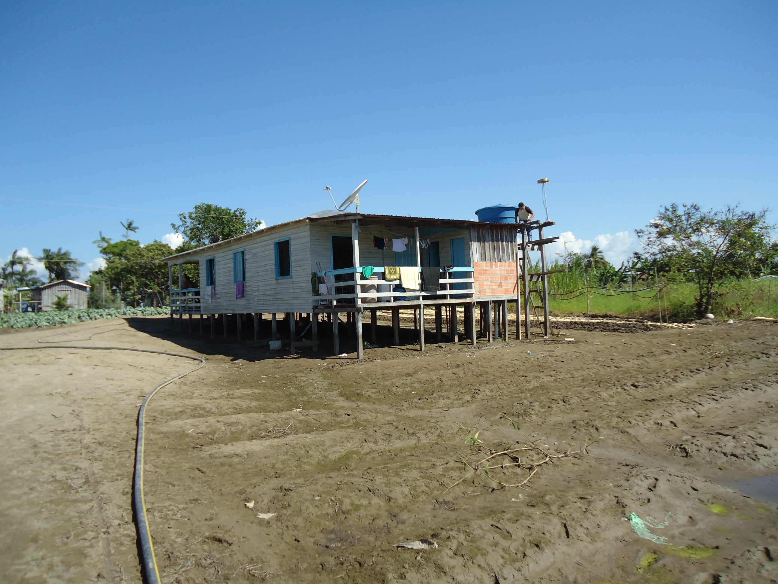
In the Amazon, because it rains so much, it is very difficult to find place to install scientific equipment. Most of the region is either the Amazon river or rainforest. For this reason, we had to install GPS Meteorological stations on people's houses (Figure 1) or on tall towers in the middle of the rainforest (Figure 2). Although the Amazon Dense Meteorological Network (20 stations, see Figure 4.) lasted just a little more than one year, a few of the stations remain will be used to continue to study rainstorms in the Amazon for many years to come.

Figure 1. GPS meteorological station, CTLO, along the banks of the Amazon River in the village of Catalao, Central Amazon. Ph. D. Student Glayson Chagas from the Universidade do Estado do Amazonas is working on the installation of the GPS Meteorology station.


Figure 3. A typical rainstorm in Manaus, the Central Amazon as seen from the GPS Meteorology station, INPA. The blue dotted line is the total amount of water vapor (called precipitable water vapor) measured using the GPS signals. The red dotted line is the temperature of the top of the clouds above the station (bigger clouds, lower temperature) and the black bars are rainfall. Note that before rainfall happens, the amount of water vapor increases strongly and after rainfall it decreases. This tell us how strong a storm is.


Figure 2. GPS meteorological station, ZF29, above the Amazon Rainforest Canopy in the Central Amazon.


Figure 4.Map of the Dense GPS Meteorological Network.


Last modified: 2019-12-26  16:24:55  America/Denver  


Please send comments and corrections to educationunavco.org.

Copyright © 2012 - 2024 UNAVCO and the GPS Reflections Research Group.
All Rights Reserved.

Funding and Acknowledgements.